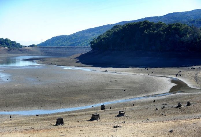
Avid boater and angler Robb Reiling has fished in the Bay Area for more than 30 years, but the outlet for his favorite pastime is slowly disappearing before his eyes.
At 38.7 percent capacity, the ramp at Anderson reservoir stands 10 feet above the water. It’s been that way since the beginning of November.
“For us fishermen to go to lakes and just see where you have literally no more access, it’s really disheartening,” Reiling said.
The rain has not yet come, and the record low of 2.56 inches for Gilroy in 2013 is a bad combination, said Reiling, with “paranoid management at the Santa Clara County Valley Water District.” He points to how the SCVWD has kept many its of its reservoirs – including Calero, Coyote and Anderson – below capacity due to concerns that an earthquake could send waters rushing across the land below in the event of a large earthquake.
“There is no reason they should have been drawn down as low as they are,” he argues.
At Anderson Dam, a 2011 study showed the Calaveras Fault, located about a mile away, could cause overflowing if an earthquake of at least 7.25 points hits the fault, according to a SCVWD board agenda memo.
Reservoirs were built to replenish the county’s underground water supply, so water is typically released in fall and summer to make room for the winter rains, according to Teresa Alvarado, the deputy administrative officer for SCVWD.
“We are still in good shape,” said Alvarado, who explains that county reservoirs are filled to 32 percent of their capacity, which is how it’s been 60 percent of the time for the last 20 years. “It’s not that unusual to see them be low at this time of year.”
Anderson isn’t the only reservoir that’s rather dry.
Uvas Reservoir, located in the foothills below the Santa Cruz Mountains west of Morgan Hill, doesn’t have capacity restrictions, but its water level currently sits at 383.8 acre-feet, or just 3.9 percent of its 9.835 acre-feet capacity, according to readings taken Monday.
And on a brisk Tuesday morning, the Calero Reservoir – located along McKean Road, west of the Bailey Avenue exit off U.S. 101 – stood like a shallow pond surrounded by yards of dry land that used to be under water. Ironically, a “No Swimming” sign stuck out in the dirt, a healthy distance from the reservoir’s edge.
Calero is at 41 percent capacity, but earthquake concerns prompted SCVWD to limit the lake’s waters to no more 46 percent of its capacity, until the dam is retrofitted.
Boaters that purchased an $80 Santa Clara County Parks Annual Venture Pass typically have access to all parks that allow boating, but in 2013 and 2014 they’ve been restricted to just Calero, with the opportunity to fish at Coyote on weekends and holidays.
There will be no rain this week, or through Jan. 28 – the longest range forecast the National Weather Service could make, according to NWS meteorologist Will Pi.
The effects of the drought continue to trickle out.
In Morgan Hill, water use typically dips from 5 million gallons a day to between 4 and 4.2 million in January as the rains kick in. Water applied to plants also evaporates more slowly during the short and cool winter days, explains Morgan Hill Utility Systems Manager Mario Iglesias.
But that’s not the case this year.
“The question, I guess, is really how are we going to manage what looks to be one of the worst droughts in recent memories,” said Iglesias. “We’re working with the district to make sure we aren’t surprised.”
He notes that the City of Morgan Hill’s 16 wells pull from the groundwater system, which is replenished by the SCVWD.
South County imports 26 percent of its water, pulls another 34 percent from local reservoirs and takes an additional 40 percent of its waters from local rainfall, according to the Santa Clara Valley Water District website.
In Morgan Hill, none of the city wells take water directly from Anderson Reservoir, but several pull groundwater from near Coyote Creek, which is flooded with water from Anderson when the reservoir’s water gates are open.
Water use restrictions or incentives to use less water aren’t in place yet, but the city is keeping a “good eye” on electronic automated equipment that monitors everything from water levels to power consumption to make sure it’s getting correct readings on wells, Iglesias explained.
In Gilroy, the City’s Water Operations Supervisor Dan Aldridge says it’s too soon to start planning water restrictions or incentives.
“We’ve still got a chance for a couple big storms to get us through the year. If we don’t get those storms we’ll have to look at conserving water,” said Aldridge.
And there is still time for the rains to come, as historically 75 percent of the SCVWD’s reservoir inflow occurs between January and March, according to the district’s website. But the SCVWD is still starting 2014 with less water than last year, with 53,100 acre-feet of carryover of surface water supplies – the above ground water that is carried over from the previous year, above and beyond operational minimums – compared to 80,800 acre-feet last year.
Local groundwater storage at the beginning of 2014 is estimated at 343,000 acre-feet, well within the normal range, explained Alvarado. The district also has nearly 263,000 acre-feet available in the Semitropic Groundwater Bank in Kern County to meet water needs in multiple dry year scenarios.
But for people like mother-daughter duo Denise and Terri Bradford, who have owned and operated the Coyote Bait & Tackle store on the southbound side of Monterey Road for 40 years, each reservoir that closes to boaters means a bigger drop in business.
“You might have a better year of fishing this year because the lakes gets a little bit more concentrated but in the long run, it’s not good for anybody,” said Bradford.
In the meantime, Reiling worries that Calero – which is receiving more boating traffic than normal since it’s the only reservoir still open full time – is going to become overfished.
“I was talking to Denise about this – five years from today Calero will be an absolutely terrible lake because there won’t be any fish left,” he warned.
Uvas
• Reservoir Storage (acre-feet *): 383.8
• Reservoir Capacity (acre-feet): 9,835
• Percent of Reservoir Capacity: 3.9
• Restricted Capacity: no
Anderson
• Reservoir Storage (acre-feet): 35,070
• Reservoir Capacity (acre-feet): 90,373
• Percent of Reservoir Capacity: 38.8
• Restricted Capacity: yes, restricted to 68 percent of capacity due to seismic stability concerns
Calero
• Reservoir Storage (acre-feet): 4,074
• Reservoir Capacity (acre-feet): 9,934
• Percent of Reservoir Capacity: 41
• Restricted Capacity: yes, restricted to 46 percent of capacity due to seismic stability concerns
Coyote
• Reservoir Storage (acre-feet): 7,629
• Reservoir Capacity (acre-feet): 23,244
• Percent of Reservoir Capacity: 32.8
• Restricted Capacity: yes, restricted to 53 percent due to active fault movement (Calaveras fault) under dam
* On average, one acre-foot of water serves two families of five for one year, according to the SCVWD


