Look south from nearly any location in lower Santa Clara Valley,
and you will see a range of mountains spanning the distant horizon.
At the highest point along that range, there is a distinct V-shaped
notch.
Look south from nearly any location in lower Santa Clara Valley, and you will see a range of mountains spanning the distant horizon. At the highest point along that range, there is a distinct V-shaped notch. A closer look will reveal a couple of transmission towers rising from the same spot. This is Fremont Peak, a topographical and historical landmark and the site of Fremont Peak State Park.
In 1846, John C. Fremont led an expeditionary force to California ostensibly to explore and survey this region. Fremont was married to Jessie Benton, daughter of Senator Thomas Hart Benton, a fervent proponent of Manifest Destiny, the belief that the U.S. was preordained to span the entire continent. Historians speculate Senator Benton unofficially suggested to Fremont that he provoke an incident in order to create a rationale for seizing land that he felt was destined to be U.S. territory.
California was Mexican territory, and the commandant in Monterey was certainly suspicious. If the purpose of the expedition was to survey the region, why are Fremont’s men an armed force hauling a large cannon? And why would the U.S. send a crew to survey land that belonged to Mexico unless they harbored acquisitive motives? Mexican officials ordered Fremont to leave California, but he retreated to the summit of Fremont Peak (then Gavilan Peak), where he hunkered down and defiantly raised the American flag. After a brief standoff, the U.S. Consul in Monterey instructed Fremont to leave. He did, leaving the acquisition of California for a later date.
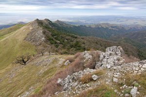
Standing atop 3,169-foot Fremont Peak, no one can fault Fremont for his choice of defensible lookouts. The view is amazing. To the southwest, I could see every building in Salinas, a good way down the Salinas Valley and the Santa Lucia Mountains beyond. The complete arc of Monterey Bay was visible. Turning right, I looked toward Loma Prieta, Coe Park, Gilroy, Pacheco Peak, Hollister and points between and beyond — in all, an unobstructed and incredible 270-degree view.
When I visited Fremont Peak State Park last week, I was reminded of another visit I made there which seems to have all the ingredients for a perfect visit to this park. We arrived at the park late in the afternoon with a picnic dinner: charcoal briquets, salmon and a bottle of wine — all the trimmings. After grabbing a picnic site, we took the short walk — perhaps a mile round trip — to the top of Fremont Peak to marvel at the view. Once back at the picnic site, we enjoyed dinner in a beautiful setting beneath the oaks.
Our visit was on a summer Saturday evening. Fremont Peak has an observatory with a 30-inch telescope, and on evenings without a full moon from April to October, it hosts stargazing programs. In addition to the observatory telescope, amateur astronomers are there with their own scopes, and they are delighted to share their scopes and point out special sights in the night sky. The night we visited, we were treated to a wonderful view of Saturn’s rings.
A naturalist’s note: As you near the summit of Fremont Peak, you begin to pass pine trees. These are Coulter pines, common in Southern California, though Fremont Peak and Mount Diablo are at the very north end of their habitat. Pick up a Coulter pine cone — very carefully. You will never see a better armored cone. Their vicious scales — long, sharp and curved — must have been designed by an evil and twisted cone maker.
For the view, or the stars, or a picnic dinner after sunset, Fremont Peak State Park has it. From San Juan Bautista, follow San Juan Canyon Road 11 miles to the park. Call (831) 623-4255 or visit the Fremont Peak Observatory Association website ( www.fpoa.net) for information on stargazing events.


