What was being called a
”
perfect storm
”
by some last week brought a fourth day of rain to California
Monday. The wind and rain pummeled areas near Los Angeles and Lake
Tahoe, but left Gilroy relatively unscathed.
By Lori Stuenkel
Gilroy – What was being called a “perfect storm” by some last week brought a fourth day of rain to California Monday. The wind and rain pummeled areas near Los Angeles and Lake Tahoe, but left Gilroy relatively unscathed.
The first of two storms to pass through Gilroy over the weekend started with a bang of thunder, lightning and strong wind Friday, but caused little damage other than minor flooding.
Gilroy received a total of 2.11 inches from the steady rain Friday through Sunday, and another .13 inches fell Monday morning, according to the Gilroy Fire Department and the National Weather Service. Just under half an inch fell Friday, 1.13 inches of rain fell Saturday, and just over half an inch fell Sunday.
To date, Gilroy has received 15.46 inches of rain since July 1, which is about 5 inches below yearly totals for entire rainfall during the past several years.
Monday afternoon’s respite from the rain was not expected to last long, the NWS said. More wet weather was to move into the area Monday evening, with showers this morning that should lessen by tonight.
The rain is expected to give way to partly cloudy skies Wednesday, which will last through the weekend, according to the NWS.
During Saturday’s rain, the fire department closed Silva’s Crossing over Uvas Creek near Christmas Hill Park, when the level of the creek rose above the road.
Other than that, the city saw few problems, said Carla Ruigh, the city’s operations services manager.
“We’ve definitely had some routine flooding from clogged catch basins and some tree problems here and there, but we have not had any major problems yet,” she said.
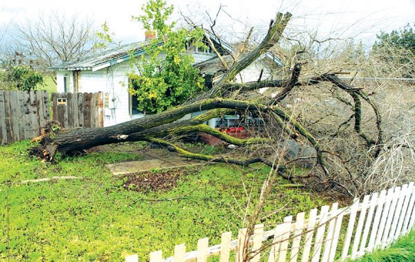
Friday afternoon, a large tree in front of a home on Leavesley Road collapsed, bringing down the home’s power line. No one was hurt.
Local reservoirs continued to collect the runoff, and though they have received a lot since Christmas, should be able to handle the rain that is on its way, said Mike DiMarco, spokesman for the Santa Clara Valley Water District. Crews will be on standby, just in case, he said.
Reservoirs countywide are about 60 percent full.
Locally, Anderson Reservoir is 57.3 percent full, Uvas is 79 percent full, and Coyote is 79.7 percent full. Coyote contains 18,520 acre feet of water, with a capacity of 23,244. The water district is making releases from that reservoir into Coyote Creek and Anderson because it’s been “taking quite a pounding – probably more than any in the county,” DiMarco said.
Before the storm, Coyote and Anderson were 53 percent full, and Uvas was 67 percent full.
Between the start of the “rain event” Friday and late Monday morning, extraordinary rainfall occurred at points from the state’s central coast south through metropolitan Los Angeles and counties farther south and east.
Gilroy Golf Course was wetter than usual and closed Monday, but was expected to open today, said Don DeLorenzo, clubhouse pro. The rain caused some erosion to cart paths and dropped tree branches on the course, but damage was minimal, he said.
Several mountainous areas of Southern California recorded more than 20 inches of rain over the weekend, including 26 inches in Nordhoff Ridge in the Ventura County mountains, and 23.5 inches in the Santa Barbara County mountains, the NWS said.
The heavy rainfall in Southern California was being generated by a sluggish low-pressure system rotating off California and drawing a low of moisture known as a “Pineapple Express” up from the subtropical Pacific near Hawaii.
A huge mudslide furiously crashed down on homes in a coastal hamlet Monday, bringing the death toll from the storms statewide to 10.
In the Sierra Nevada, the storm produced heavy snow during the weekend that stalled an Amtrak train, and forced them to reroute others. Some passengers were bused to their destination. The snow also shut down the airport at Reno, Nev., for the second time in a week, and halted highway travel across the mountain range.
Since Dec. 28, up to 19 feet of snow has fallen at elevations above 7,000 feet in the Sierra Nevada, with 6 feet at lower elevations in the Reno area. Meteorologists said it was the most snow the Reno-Lake Tahoe area has seen since 1916.
The Associated Press contributed to this report.


