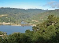
As you descend Highway 17 from Santa Cruz into Los Gatos, steep
chaparral-covered slopes rise abruptly beyond Lexington
Reservoir.
As you descend Highway 17 from Santa Cruz into Los Gatos, steep chaparral-covered slopes rise abruptly beyond Lexington Reservoir. These slopes are the northern portion of Sierra Azul Open Space Preserve. At 17,400 acres, Sierra Azul is the largest and surely the most rugged of the Midpeninsula Regional Open Space District’s 25 preserves. From its northern boundary here, it stretches all the way to Mount Umunhum and Almaden Quicksilver County Park.
In midsummer those steep, south-facing slopes are not inviting. The sun relentlessly pounds a landscape that only supports drought-tolerant shrubs, and has relegated water-loving trees to shaded canyons. I would not want to be up there at midday in August.
But it’s September, and it’s been cool. There will be a lot of “up,” but the reward for climbing steep hills is often a wonderful, I’m-king-of-the-world moment when you reach the top and gaze across the vast landscape beneath your feet.
Getting to the trailhead is a bit tricky. Above Los Gatos take the Bear Creek Road exit off southbound Highway 17. Cross over the highway. Enter northbound Highway 17 and exit a half mile later at Alma Bridge Road. Across the dam and past Lexington County Park parking lot, the road follows a narrow inlet bay. Just beyond the inlet look for an inconspicuous green gate on your left. That’s the bottom of the Limekiln Trail where my hike ended. I began a half mile up the road at a second green gate, the beginning of Priest Rock Trail.
Perhaps because the actual trailhead is on county park property, and the preserve boundary is up the trail, there are no preserve maps available there. You can download a Sierra Azul map at www.openspace.org. You’ll want one.
In the cool of the morning, I started up the shaded Priest Rock Trail (a fire road), which switched back and forth on a manageable grade through a forest of mostly oaks and bays. Each time I stopped to rein in my breath, the view over the reservoir to the hills beyond improved. Finally the trail emerged from the trees into a chaparral of fruiting coffeeberry, toyon and coyote brush.
It is easy to think that the coast is just over the hill from the Santa Clara Valley, but as I reached the open ridgetop, I was surprised by how much rough, mountainous land is hidden back there. Large canyons dropped away on each side of me with hints of many others beyond.
On this open stretch of the Priest Rock Trail, you can see the path twist up the slope ahead of you. Some portions of this last stretch were simply inhumane — silly steep. At the top, I had to search along the solid wall of shrubs there until I found a couple narrow slots with a view down into the Almaden Valley.
At the trail junction half way down, I took the Limekiln Trail which drops off the ridgetop and down into Limekiln Canyon. While it looks into an the scarred hillside of Limekiln Quarry, the trail is a shaded walk that descends to a still-running creek with a nice variety of riparian trees: bigleaf maple, white alder — I even saw some rare western yew.
If you are in search of a quest Sierra Azul above Lexington Reservoir is for you. If you arrange a car shuttle you can start here and walk all the way to Almaden Quicksilver County Park, a 12-mile journey that will feel like 20. But oddly, in contrast to the predominantly steep and exposed trails up above, Limekiln Trail is a perfect place to escape the summer heat along a cool forested creek.


