Over two-plus years, California voters ripped from state
politicians the duty of drawing electoral boundaries and put it in
the hands of a citizen-run committee. Now the fruits of that
committee’s labor could soon become reality
– and law before the November 2012 elections – bringing changes
to Gilroy and other communities statewide.
Over two-plus years, California voters ripped from state politicians the duty of drawing electoral boundaries and put it in the hands of a citizen-run committee. Now the fruits of that committee’s labor could soon become reality – and law before the November 2012 elections – bringing changes to Gilroy and other communities statewide.
The new maps, showing new boundaries for the state’s assembly and senate districts, as well as the U.S. House of Representatives, could be finalized by Monday – 18 days after the Citizens Redistricting Commission unveiled final drafts for public scrutiny.
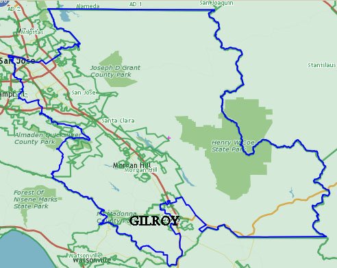
The changes could usher in major shifting, including changing the state’s 28th district – which includes Gilroy – to a new moniker: No. 30.
Mayor Al Pinheiro said he’d be happy with the maps as long as they kept the Garlic Capital in the same electoral regions as Morgan Hill and other similar communities.
“The bottom line is to stay with common goals and common areas,” Pinheiro said. “That was kind of our voice. Having somebody even in Watsonville, there’s some commonalities there. That’s important that we stay together.”
In November 2008, voters passed Proposition 11, which gave a citizen commission the right to draft the state’s senate and assembly boundaries. Two years later, a successful Proposition 20 vote extended the commission’s right to redraw the state’s congressional boundaries.
The Commission is comprised of 14 members: five Republicans, five Democrats and four who declined to give a political affiliation, according to the commission’s website, “We Draw The Lines.”
Under the current maps, drawn every 10 years following the U.S. Census count, Gilroy shares districts with San Jose and other Silicon Valley cities, but is separate from nearby Morgan Hill.
In the proposed state senate boundaries, Gilroy would be in the same region as Watsonville, Santa Cruz and other cities, extending as far south down the coastline as San Luis Obispo.
Beyond a numeric name changes, alterations are also due to the assembly boundaries, as Gilroy and communities south of San Jose are isolated from the heart of Silicon Valley and much of Santa Clara County.
In a proposed congressional map, a sliver-like district shared by Gilroy, Los Gatos and Santa Clara goes away, as Gilroy joins Morgan Hill and San Jose yet is split geographically. Gilroy’s eastern half in the suggested map will split off, joining Watsonville and Santa Cruz in a separate region. Currently, Mike Honda represents Gilroy in the House of Representatives, though if Gilroy is divided among two districts, presumably two representatives would represent the area.
In June, Gilroy Chamber of Commerce President Susan Valenta sent a letter to the redistricting commission stating the Chamber’s opposition to the proposed senate and assembly maps.
Valenta said the maps did not take into consideration “the best interests of our community” as they would split Santa Clara County four times, potentially keeping Gilroy from some of its county neighbors.
“Gilroy shares communities of interest with our neighbors in Santa Clara County: we are not on the coast and we are not in the Central Valley,” Valenta wrote. “Gilroy has a long heritage, and our roots are deep in this (Santa Clara) valley’s history.”
Jane Howard, executive director of the Gilroy Visitors Bureau, however, said the proposed state senate map “makes some sense from a tourism perspective.”
The proposed map would pair Gilroy and Morgan Hill and include Watsonville, Santa Cruz and other cities down the coastline to San Luis Obispo. It could strengthen already growing tourist ties between Gilroy and coastal communities, Howard said.


