Before it even has a chance to dry off, Gilroy is about to
receive another wintry punch from Mother Nature. Following three
days of precipitation – including light snow and brief hail
Saturday afternoon
– a new storm system will move into the region by Tuesday night,
bringing more rain and the potential for flooding in some
areas.
READER PHOTOS: Gilroyans snapped pictures of the Saturday snow.
Click here for photos.
Before it even has a chance to dry off, Gilroy is about to receive another wintry punch from Mother Nature.
Following three days of precipitation – including light snow and brief hail Saturday afternoon – a new storm system will move into the region by Tuesday night, bringing more rain and the potential for flooding in some areas.
The National Weather Service issued a hazardous weather outlook Monday for the Santa Clara Valley, as this latest storm would come on the heels of a heavy two-day downpour that dumped 2.19 inches of rain from Thursday afternoon through Saturday afternoon on Gilroy, according to Austin Cross, a meteorologist for the National Weather Service in Monterey.
Tuesday night’s storm might also bring gusty winds capable of toppling trees and causing power outages, he said.
“It looks like it’s going to pack quite a punch,” he said.
Cross said wind gusts could climb to 40 mph, and rainfall totals might reach up to an inch along the valley floor.
“If the rain sticks, we might see some minor flooding,” Cross added.
That could be a problem for a region already inundated with recent rain. Large volumes of rain in Gilroy have washed into Uvas Creek, and the Uvas Reservoir was at 101.2 percent capacity as of 3:05 p.m. Monday, according to the Santa Clara Valley Water District.
The reservoir, located about 11 miles northwest of Gilroy, has been spilling into Uvas Creek for about a week, said Mayla Magill, customer relations manager for the water district. She said it may continue to spill for the remainder of this week, but the water district wasn’t expecting any significant problems related to this newest storm.
“It really depends on the storm – how it comes across the county and how it comes across Gilroy,” she said.
Jeff Micko, water supply operations manager for the water district, said he didn’t expect the storm to be as powerful as other recent systems, but there would be “a little bit more water coming down Uvas Creek.”
Micko said the reservoir’s control valve was “wide open” in an attempt to lower the water level. He said it was something the water district does every year in an attempt to reach a fillage goal, which is about 85 percent this year.
“It’s our practice at this time of year to keep the reservoir less than full,” he said.
Micko said the control valve was opened prior to the last week’s storms.
Gilroy also got a rare taste of snow Saturday afternoon. Snowflakes fell lightly about the city around 3:30 p.m., and residents and business patrons hopped outside to experience the frosty event.The snow didn’t stick in many places because temperatures in town stayed in the high 30s and low 40s.
Matt Bozzo, who lives on Furlong Avenue just east of Gilroy, said snow fell on his home for about 30 minutes.
“It almost looked like a blizzard it was coming down so hard,” Bozzo said, “besides the fact that none of it was accumulating on the ground.”
Bozzo said, however, he had friends in Morgan Hill and San Martin who were able to toss snowballs and make snow angels where they lived.
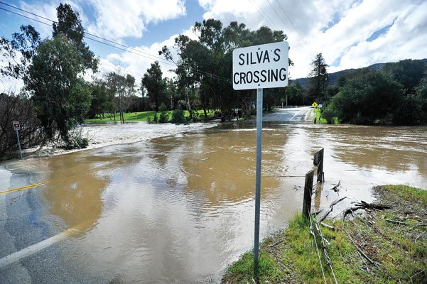
Miller Avenue between Uvas Park Drive and Santa Teresa Boulevard was closed Friday due to flooding. Drivers stopped and got out of their vehicles Friday afternoon to get a glimpse of a flooded Silva’s Crossing.
There was also a report of flooding at Frazier Lake Road near Highway 152 during Friday morning, according to the California Highway Patrol.
The wintry weather is far from over, Cross said. Another storm could bring more rain to the area Saturday and Sunday.
Cross said it was hard to predict what to expect from that storm, but its likely there would be a “significant amount of rain again.”
He said on-and-off storms were common during this time of year.
“That’s often the kind of winter pattern we see,” Cross said. “We kind of got a break in January, and now we’re back in the winter swing of things.”
Despite the stormy conditions, the weekend was mostly safe, according to area fire and law enforcement officials.
Jim Crawford, battalion chief for the South Santa Clara County Fire District and CalFire, said there were no major weather-related incidents during the weekend that required response from area firefighters.
Jaime Rios, California Highway Patrol officer, said the CHP was prepared to assist Caltrans in closing roads if conditions became snowy or icy, but the weather never turned that bad.
Rios said it did snow lightly in Salinas, his hometown, but “it wasn’t crazy snow.”
Tuesday’s storm
– Heavy rain lasting into Thursday
– Rain totals possibly eclipsing two inches in the hills, one inch on the valley floor
– Minor flooding likely
– Wind gust reaching as high as 40 mph in some areas
– Overnight low of 43 degrees
READER PHOTOS: Gilroyans snapped pictures of the Saturday snow. Click here for photos.


