On Tuesday, the County of Santa Clara Board of Supervisors
approved the adoption of a map that sets the new supervisorial
districts that must be done every 10 years when a new Census is
completed.
The new boundaries assure that the county’s 1.78 million
residents are represented by one of five county supervisors. The
Voting Rights Act of 1965 calls for each district to be as nearly
as equal in population as possible.
On Tuesday, the County of Santa Clara Board of Supervisors approved the adoption of a map that sets the new supervisorial districts that must be done every 10 years when a new Census is completed.
The new boundaries assure that the county’s 1.78 million residents are represented by one of five county supervisors. The Voting Rights Act of 1965 calls for each district to be as nearly as equal in population as possible.
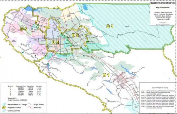
The ideal target population per district would be 356,320 residents. Under the map approved today, population shifts between districts and range from minus 5.2 percent to plus 4.4 percent compared to the ideal target. Map 1, Revision 1 was offered by board President Dave Cortese, following a decision two weeks ago to keep four alternative maps under consideration.
For the Sounty County – District 1 – the changes affect the Mount Hamilton area and most northeast areas of the old District 1, which is now a part of the new District 3. No neighborhoods in Morgan Hill, San Martin or Gilroy will be affected by the border change.
For Maps go to: http://bit.ly/New_District_Maps
KEY CHANGES
– Area 1 – A portion of Sunnyvale moves from District 3 to District 5, from El Camino Real northward along Mathilda Avenue and Central Expressway
– Area 2 – Monte Sereno and an unincorporated pocket moves from District 5 to District 1
– Area 3 – A portion of San Jose moves from District 2 to District 4, from Park Avenue north to The Alameda; Montgomery Street is the eastern boundary
– Area 3a – A portion of San Jose moves from District 4 to District 2, a minor adjustment from Park Avenue and Los Gatos Creek to Montgomery Street
– Area 4 – A portion of San Jose from District 2 to District 4; the existing boundary which follows Los Gatos Creek, Fruitdale Avenue, Meridian Ave and Curtner Ave is pushed east along Bird Avenue, Malone Road and Almaden Road to Almaden Expressway
– Area 4a – A portion of San Jose from District 4 to District 2; a minor adjustment from Curtner Avenue and Almaden Expressway to Almaden Road
– Area 5 – A portion of San Jose moves from District 4 to District 1; current boundary moves from Los Gatos city limits and Blossom Hill Road north to Highway 85 between Bascom Avenue on the west and Almaden Expressway on the east
– Area 6 – A portion of San Jose moves from District 3 to District 2; area bounded by Aborn Road, Brigadoon Way, Eaglehurst Drive and Silver Creek Road is now a part of District 2
– Area 7 – A portion of San Jose from District 1 to District 2; brings current boundary at Senter Road and Coyote Road south to Blossom Hill Road between Monterey Highway and Highway 101
– Area 8 – A portion of San Jose and Unincorporated Area moves from District 1 to District 3; realignment takes the eastern-most boundary of District 3 and pushes it to the County line; the southern boundary of District 3 generally follows this description – beginning at Highway 101 and Silver Creek Valley Road, eastward along Silver Creek Valley Road following the San Jose city limit boundary, eastward to San Felipe Road, eastward to Smith Creek and further eastward along the Morgan Hill Unified School District Boundary.
***
“Map 1, Revision 1 takes into account various aspects of the public feedback to the Citizens’ Redistricting Advisory Commission and the Board and has been tweaked for the best possible outcome,” said Susie Wilson, the Citizens’ Redistricting Advisory Commission Chair.
The board credited President Dave Cortese and his office for working to find compromises that addressed the population shifts as well as some of the illogical community splits that exist in the current Supervisorial Districts.
“The process to solicit community input was extremely well-received,” said Supervisor Mike Wasserman, District 1. “Susie Wilson is to be commended for her leadership as chair of the Citizen’s Redistricting Commission.”
Supervisor Ken Yeager, District 4, said, “One thing I appreciate about the map is that it incorporates many of the comments made during the public hearing. Also, Rose Garden and Willow Glen are now in one district, which my constituents wanted.”
“The bulk of the work was done by the Citizens’ Redistricting Advisory Commission,” said Cortese. “We were able to take in their recommendations, as well as concerns expressed by various members of the community and arrive at a solution that everyone could support.”
BACKGROUND
On June 7, the Board held a public hearing to consider recommendations of the 11-member Citizens’ Redistricting Advisory Commission, appointed last December. The advisory group’s mission was to make recommendations to the Board for the adjustment of supervisorial district boundaries to reflect population shifts identified in Census 2010. The group held several meetings to solicit public input and presented a number of alternative maps to the Board. On June 7, four of 13 possible maps were advanced for consideration. Today, the board voted unanimously to approve the Map 1, Revision 1.


