One campus would have about 2,000 students, other satellite
school will have 1,000 enrollment
The relocation of ball fields, a high school addition, adjustments to the town center lake and subtle changes to the land use along Coyote Creek were the main focus of during a community meeting surrounding Coyote Valley development.
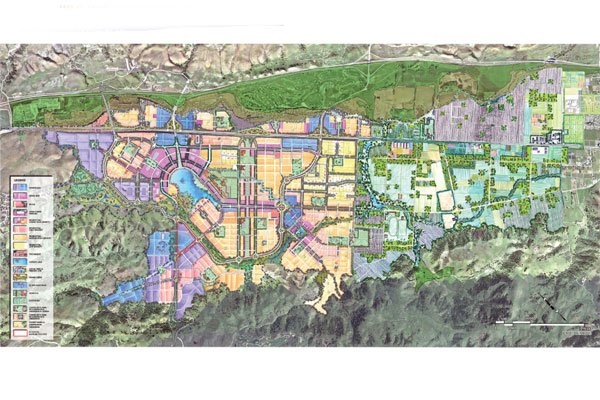
Stakeholders, including property owners, community members and environmentalists filled the club room at the Coyote Creek Golf Club to hear the latest refinements that the Coyote Valley Specific Task Force made to the 7,000-acre development plan Thursday night before it is taken to the San Jose City Council in March.
“We’ve all been in the category of life goes on,” said San Jose planner Doug Dhalin. “As some things have been approved, other things come into consideration.”
An extensive part of Thursday’s discussion was the task force’s plan to divide its original idea of a 60-acre Morgan Hill Unified School District high school into a 40-acre high school with a 20-acre satellite high school conjoined with Gavilan Community College.
“Instead of having one high school with 3,000 students, you’ll have one high school with 2,000 and a smaller high school with 1,000,” Dhalin said. “The 40-acre high school will be a huge part of the town center. People will be able to get dinner in town and catch a football game afterward.”
Sal Yakubu, the principal planner for San Jose’s Planning Commission, said that the task force has made several agreements with the MHUSD on grabbing a partnership with Gavilan to share some of their facilities and costs of taking on a satellite high school while the 40-acre high school will be located in the heart of Coyote Valley.
“The 40-acre high school, on the other hand, will serve as a main civic amenity,” Yakubu said. “We plan to have it based in the town center where it is accessible to all people.”
The task force also made small refinements to the size and location of the town center man-made lake that will sit in the middle of 25,000 homes.
Concept maps suggest changes in land usage around the lake, replacing residential land introduced on one map with a parcel of business land on another, with an adjustment to the lake shape at the south end.
*0002000004D900000933


