A modest but solid 3.9-magnitude earthquake near Morgan Hill late on New Year’s Day jolted the Bay Area and Central Coast .
Five days later, light sleepers in Gilroy were rattled twice in the early morning of Monday, Jan. 6, by two minor quakes: A 3.0 earthquake struck in the unincorporated area of Santa Clara County about 2.5 miles southwest of Gilroy at 1:37am, then in almost the same spot along the San Andreas Fault four hours later later, at 5:36am, a 2.7 was recorded by the US Geological Survey.
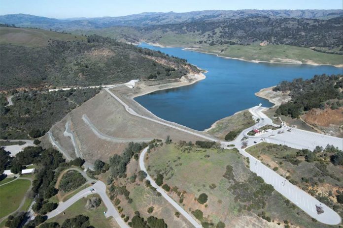
There were no reported aftershocks of the Morgan Hill temblor, but the location of its epicenter, just 2 miles east of the Anderson Dam on the Calaveras Fault at the northeast edge of the city, did send out new ripples of anxiety about the safety of the seismically shaky earthen dam set to be replaced in the new decade.
“Next to the damn dam,” was the blunt reaction of one Gilroy resident on Facebook to the 11:16pm earthquake on Jan. 1.
A Morgan Hill resident summed up the experience described by dozens of social media observers when he wrote, “Felt the bed move, and loud banging on the wall woke us up.”
The quake rattled shelves as far north as Paradise and Reno, as far south as Salinas and as far east as Modesto, but no damage or injuries were reported.
The dams’ owner, Valley Water, has listening devices at all of its reservoirs and dams that measure and record “ground acceleration,” distance from the epicenter and earthquake magnitudes.
“We will send out a post-earthquake dam evaluation program team after significant earthquakes (4.5 magnitude or larger) to inspect the dams for any signs of damage,” said Valley Water spokesman Matt Keller on Jan. 3, in response to questions from this newspaper.
For smaller quakes, like the one reported east of the Anderson Reservoir on New Year’s Day, Valley Water staff conducted visual inspections the following day, he said.
“There were no issues at any of our dams/reservoirs following Wednesday night’s quake,” reported Keller.
Currently, both dams east of Morgan Hill, backing up water in the Anderson and Coyote Creek reservoirs, are below their designated safety capacities, he said.
Anderson Reservoir is at 30.2 percent of capacity, below the state’s Division of Safety of Dams interim restriction, and its smaller upstream sibling, the Coyote Creek Reservoir, is at 24 percent of its permanent restriction capacity, below the permanent state Division of Safety of Dams restriction, said Keller.
The Anderson dam is to be replaced in a $1 billion project beginning in 2022 for seismic safety, flood control and drinking water capacity reasons, according to the district.
To check real-time reservoir levels, visit alert.valleywater.org/rgi.php.
The musical score for the last few days of 2019 and the first few days of 2020 was definitely rock & roll—light rock, but bumpy nonetheless—as more than 20 small to moderate earthquakes were reported between San Francisco and Los Angeles from Dec. 27 to Jan.3, according to the USGS.
The USGS said the 3.9-magnitude Morgan Hill quake, originally recorded as 4.1, was 2 miles east of Anderson Lake, and 5.6 miles north of downtown Morgan Hill. It occurred at 11:16 pm along the Calaveras Fault, which extends from the Oakland Hills to near Hollister, where it connects with the San Andreas Fault.
Five small quakes were reported along the San Andreas Fault south of Hollister in San Benito County last week:
- A 3.4-magnitude quake at 8:40am Jan. 3, about 16 miles from King City, and nearly 12.5 miles northeast of San Lucas;
- A 2.7 quake at 8:34am Jan. 2, 2.5 miles southeast of Pinnacles;
- A 2.6 quake at 12:30pm, Dec. 31, 7.5 miles southeast of Pinnacles;
- A 2.8 quake at 8:16pm, Dec. 29, 10 miles southeast of Tres Pinos; and
- A 2.5 quake at 4:59am, Dec. 27, 4.4 miles northeast of Pinnacles.
The largest California earthquake of the New Year, with a magnitude of 4.0, occurred at 2:13am Jan. 2 about 15.5 miles offshore from Santa Barbara, reported the USGS.
Seven small earthquakes of up to 3.1 magnitude rumbled through the Southern California desert 4 miles west of Searles Valley Dec. 30-Jan. 3 on the western edge of Searles Lake, a dry lake bed southwest of Death Valley.


