In California’s early days, placer miners swarmed to the Sierra
foothills in search of gold. Many of the mining towns that sprouted
near the main rivers that drain the high country are strung
together along Highway 49.
In California’s early days, placer miners swarmed to the Sierra foothills in search of gold. Many of the mining towns that sprouted near the main rivers that drain the high country are strung together along Highway 49. Towns like Nevada City, Angels Camp and Jackson are rich in history, but the feel of that long-ago time has been lost to spiffy antique shops and quaint inns that draw the tourist trade.
A few mining settlements remain where the only changes that have occurred since the last miner left have been made by brutal weather conditions and lots of time. On a recent trip to Yosemite, I visited one such mine perched high on the Sierra crest less than 2 miles from the car.
The long but lovely drive along Highway 120 leaves the east side of Yosemite National Park at Tioga Pass. Immediately before the entrance station at the pass, I parked in a small lot on the left side of the road. I had driven directly from home (elevation 500 feet) for a late-afternoon hike here (elevation 9,943), but the beginning of this trail didn’t seem to care about my need to acclimate. The first half mile climbs a steep 500-foot ridge – ouch! – but when you can no longer gulp air quickly enough, stop, turn your gaze from your shoe tops and look across the valley behind you. Beyond beautiful Dana Meadows looms reddish Mount Dana (13,053 feet) and further right, separated from Mount Dana by a lovely valley, is Mammoth Peak (12,117 feet).
On several previous visits here, I have walked no further than the top of the ridge – a lovely spot and a worthwhile destination. As you wander up the gentle slope to the right toward Gaylor Peak, you pass from the forest into alpine country. The last remaining trees are whitebark pines that grow in a low krummholz form (German for “twisted tree”), trimmed as neatly as hedge clippers by the brutal winds that rake these slopes. Sunset here is fabulous.
But on to the mine. On the far side of the ridge is a broad and barren basin with Middle Gaylor Lake tucked just beneath you. I dropped down to the lake, then traced its shore until I reached the stream coming down from Upper Gaylor Lake. The walk along this stream is a lovely example of the wonderful contrasts that one sees in the high country. Here, in this stark and barren setting, is a delicate and picturesque creek bouncing down through soft green tussocks punctuated with alpine flowers.
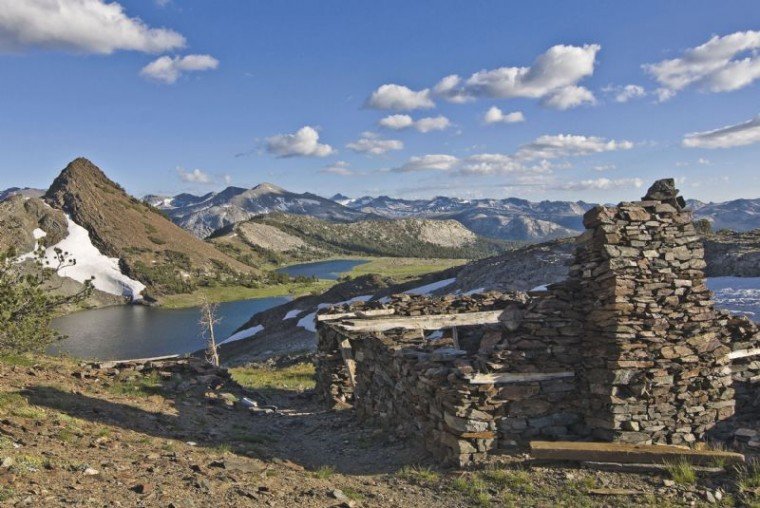
Over a lip, the upper lake finally appeared. On the rocky slope beyond, I could see some sort of structure. While the aspect of the trail was gentle, the thin air made each step a struggle. But finally I reached the remains of the mining settlement of Dana and the Great Sierra Mine.
Looking at the decrepit remains of “cabins” built out of the flat metamorphic rock all around, it is a head-scratching task to imagine living and working in this desolate wind-swept place. Poised right on the Sierra crest are lovely views down to Mono Basin on one side and Yosemite’s high country on the other. Still, it must have been a tough life. The largest cabin, perhaps 8 feet by 10, had a hearth and a wood frame doorway and window as well as a collapsed wooden roof. Others were low and small and appeared to be built only for sleeping miners.
It only took a few years for operations here to finally shut down in 1884. Smart move, I’d say. While it’s no place to live, the mining settlement of Dana – a 3.6-mile round trip hike – is a lovely place to visit.


