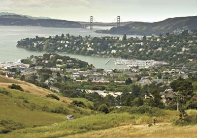
I stood at the top of a bayside ridge. The grassy slopes dappled
with spring flowers dropped away in every direction. I was
alone.
I stood at the top of a bayside ridge. The grassy slopes dappled with spring flowers dropped away in every direction. I was alone. The only sound I heard was the wind, pushed by a threatening sky, stirring the grass around me. Where else in the world, I wondered, can a person stand in such natural beauty and gaze across a bay toward one of the world’s most beautiful cities?
I grew up in southern Marin County. Recently a friend’s milestone birthday celebration drew Renee and me back there for a visit. We took two short walks that can be easily tacked onto any visit to the North Bay or San Francisco. Both of these walks are world class — little gems that highlight what makes the Bay Area so special.
The Golden Gate National Recreation Area includes the Marin Headlands, the vast expanse of land north and west of the Golden Gate Bridge. Trails honeycomb thousands of acres here along Marin’s border with San Francisco Bay and its Pacific Ocean shoreline outside the gate. The trail to Tennessee Valley connects with others if you would like to see more of the headlands, but the short walk out to Tennessee Cove can fill a couple hours in a day of other plans.
To get to the trailhead, take the Mill Valley/Stinson Beach exit off Highway 101. In about a half mile, turn left on Tennessee Valley Road and follow it to the end. When I was a kid, before the GGNRA, you would rarely see a car parked here. But these days, you won’t be alone. The mostly level trail twists 1.7 miles through the valley, past a lagoon and finally to a rough-and-tumble patch of beach.
Tennessee Cove was named for one of the hundreds of ships that were lost along this shore. At low tide, look for the Tennessee’s anchor, all that remains from the 1853 wreck. On the cliffs above, look for old military lookouts. Bring something warm. A lovely day in Mill Valley can still mean Candlestick Park weather at the cove.
Old St. Hilary’s Open Space Preserve is only 122 acres, but once there, you will quickly realize you are walking one of the most stunning sites anywhere. Near the tip of the Tiburon Peninsula, the view from the crest of the preserve ridge top will have you spinning to take in all 360 degrees. How about Mount Tamalpais, Angel Island, Golden Gate Bridge, San Pablo Bay and the San Francisco skyline for starters? Just below and to the south were the yacht harbors and hillside settings of Tiburon, Belvedere and Sausalito looking every bit like Mediterranean villages along the French Riviera.
To get there, exit Highway 101 at Tiburon Boulevard. After 3 1/2 miles or so, turn left at Lyford Drive. Work your way up, taking Sugarloaf, then Heathcliff to its end. Bring grandma and your most virulent anti-hiker. This is just a stroll with all the rewards given at very little effort. Driving down the hill after your walk, look for the preserve’s namesake, Old St. Hilary’s church (once photographed by Ansel Adams) sitting on the hillside at the bottom of the preserve. The wildflower preserve adjacent to the church supports the tiburon jewelflower that grows only on that slope.
Short and easy, you can tack either of these walks onto an itinerary busy with other activities, yet I suspect they will be the day’s most memorable part. They are perfect examples of the vastness and the quiet beauty that we enjoy in the Bay Area just a few steps away from the hustle and bustle.


