Would you rather visit Mukuntuweap National Monument or Zion National Monument? In fact, they are the same place. As I researched the origin of the name of Zion National Park (originally a National Monument), I was certain I would find a story related to the history of Mormon settlement in southern Utah. To my surprise, in 1918, the acting director of the National Park Service changed the name from Mukuntuweap to Zion simply for marketing reasons. He felt that the Zion National Park name would draw more visitors.
Last week, it drew me and a group of friends who converged in nearby St. George, Utah for several days dedicated to exploring this beautiful park. Twice before, I had driven through without stopping to give it the attention it deserves. Even through a car window, the park impresses. I was looking forward to a closer look.
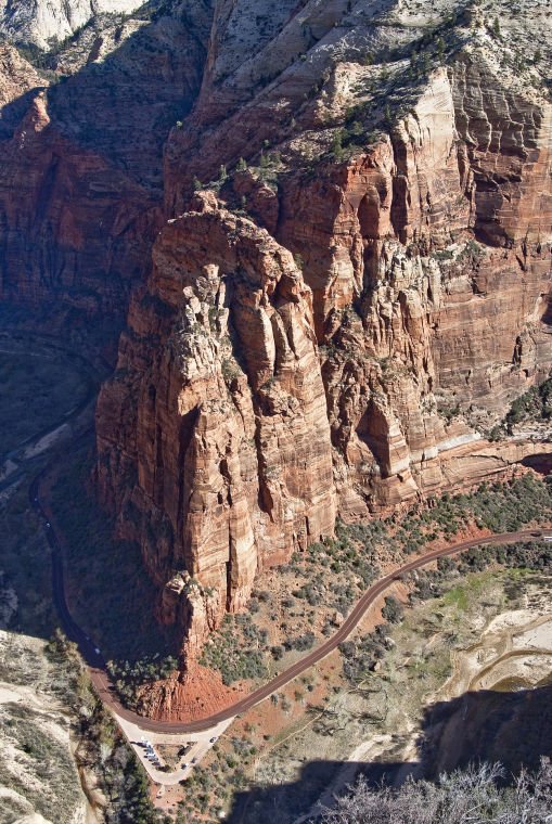
The focus of any short visit to Zion National Park is Zion Canyon. The fifteen-mile road up the canyon follows the North Fork of the Virgin River until it pinches down to “The Narrows,” a slot too tight for car travel. Along the road are regular parking lots, each one a portal to hiking trails that lead out of the valley floor to slot canyons, weeping rock overhangs, and spectacular overlooks above.
We entered Zion Canyon on a fresh and crisp morning. What a sight! The cottonwoods that inhabit the forest floor along the river were just leafing out creating a delicate yellow-green contrast to the muscular red-hued cliffs rising thousands of feet overhead. Zion contains the same layer cake of geological formations one sees in the Grand Canyon and other Colorado Plateau parks. The exposed layers vary from park to park due to the different elevations at each site.
It won’t take more than a few minutes in the park until you hear about Angel’s Landing. It is the main notch that every hiker seeks to put in his belt. Imagine a watered-down version of the walk to Half Dome in Yosemite. The hike is shorter – five miles round trip, and it is not as great a climb – 1,488 feet to the 5,790-foot summit. But nearly every inch of the trail is one step away from a spectacular sheer vertical face. Beyond Scott’s Lookout, things get serious. A series of chain railings secure you along a tightrope path with inches separating you from a spectacular death. I was surprised to read that the Park Service officially recognizes only five deaths on this trail.
This hike will either scare you to death or thrill you to death. We started early in the morning to avoid the increasing trail traffic as the day goes on. From the valley floor, the lower portion of the route to Angel’s Landing appears so steep that I could not imagine that there was a trail etched through that steep rock. I was surprised to find more than a simple trail. The lower portion is a paved thoroughfare wide enough for hikers to walk three abreast. Built in the 1920’s, the trail is an engineering marvel with an impressive masonry retaining wall supporting nearly every switchback.
Up above, the path changes from pavement to native sandstone and climbs up a narrow ridge, sheer vertical drops on each side. What a thrilling walk! With hair-raising exposures come unsurpassed views up and down a truly stunning valley. The peak broadens just enough to allow a secure and comfortable perch without hindering the view.
Time for lunch, photos, and looking…and looking.


