Near Bozeman, in southwestern Montana, three young rivers — the
Jefferson, the Madison and the Gallatin — slide down the
Continental Divide and join forces to create the Missouri
River.
Near Bozeman, in southwestern Montana, three young rivers — the Jefferson, the Madison and the Gallatin — slide down the Continental Divide and join forces to create the Missouri River. After Lewis and Clark pioneered the 2,341-mile route from St. Louis to these headwaters, a generation of trappers and explorers whose names still live in the legend of the American West ventured here for furs and adventure.
Southbound on Montana’s Highway 287, Renee read the guidebook blurb about our destination, Bozeman. It said that outdoor activities were “practically out the back door” and touted the excellent restaurants and art galleries, calling Bozeman “Montana’s most beguiling urban experience — though it’s not to be mistaken for the real Montana.” That sounded good to our California sensibilities.
Montana is called Big Sky country, but the tag overlooks the fact that everything there is big. In the valley that holds Bozeman and the Missouri River headwaters, that sky arches across a reach of land that looks big enough to swallow Connecticut and maybe a couple more of those cute New England states. From the valley, high mountains etch the horizon in every direction: The Tobacco Roots are due west, the Madisons to the southwest, then the Gallatins — all miles away yet seemingly close enough to touch.
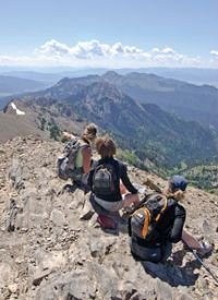
The southern tip of the Bridger Range touches Bozeman on its northeast edge and completes the mountainous circle around the Gallatin valley. Our hosts, Scott and Holly, kicked off our visit with a morning walk up Mount Baldy at the south end of the Bridger’s where Montana State University students have marked their territory with a huge white “M” that overlooks Bozeman. The spectacular views across the valley make this a perfect place to get the lay of the land.
Our host, Scott, was raised growing wheat on a ranch near Billings, a couple hours east of Bozeman. He and Holly have built a life in Boston, but you can’t take the Montana out of Scott. They return every summer, and Scott’s enthusiasm and knowledge of the region spill over and are infectious. He and I share a mountain itch, so one morning Scott took me to a favorite spot where he said the scratching was great.
Highway 86 skirts the southern edge of the Bridger Range before swinging north along its eastern flank. We turned onto a dirt road that took us to the trailhead for Sacajawea Peak, at 9,656 feet, the highest point in the Bridgers. After a half-mile walk through a forest of spruce and fir, we popped above timberline and climbed a series of switchbacks across snowfields and rock scree toward a saddle in the ridgeline. All the while, Sacajawea loomed on our left. It was an imposing goal.
Once we reached the saddle, the show began in earnest. Our final ramble to the summit was an orgy of immense views, alpine flora and mountain goats dancing across steep slopes and impossible footing. After a snack, an entry in the summit register,and lots of looking, we headed down.
Let’s review: We walked a very manageable five miles, climbed 2,000 feet from the trailhead to an impressive 9,656-foot alpine peak and were back home by lunch. Not bad.
The guidebook was right. Walking downtown Bozeman was like walking Pacific Avenue in Santa Cruz: art galleries, foo-foo coffee shops, bookstores and hip eateries. Bozeman has all of the cultural diversity in the midst of a beautiful outdoor playground.
Before our visit, Scott and Holly scolded us for not setting aside enough time to fully see the area. They were right. It was our only disappointment.


