Landmarks stand as beacons of both geography and time. The South
Valley contains many well-known regional sites residents here use
to reference their location, not only along the roads of asphalt
but also on the roads of history.
Landmarks stand as beacons of both geography and time. The South Valley contains many well-known regional sites residents here use to reference their location, not only along the roads of asphalt but also on the roads of history.
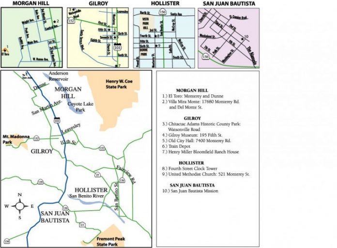
Countless landmarks can be found in our region and they paint a vivid picture of the colorful heritage shared by the region. The landmarks range from mountain peaks seen from miles away to the homes of local pioneers who settled here. Hollister Train Depot
In the 1860s, railroad construction was changing society, similar to the way the Internet is changing it today. The long ribbons of iron rails were an efficient means of sending goods and people over long distances.
In that decade, Hollister was a sleepy farming hamlet of less than 300 people, most of whom tended the cattle and sheep that grazed in the area. Growing feed hay was a primary business in the area, and in that decade, horse-driven wagons were the only means available to bring this crop to other locations for sale.
Farmers in the region realized the necessity of luring the Southern Pacific Railroad to build a branch line from Gilroy to a location in San Benito that was easily accessible for hay haulage. Originally, the Spanish-mission village of San Juan Bautista was considered, as it was the largest community in the area. But most of the hay was grown in the southern region of the county, and quicksilver was also being mined in the New Idria region. Railroad officials decided a more convenient location in the area was required for a railroad stop. The village of Tres Pinos was chosen.
During construction of the branch line, a small depot station was also built in Hollister in the late 1860s to serve the needs of the villagers there. Railroad service officially began on July 13, 1871. With passenger train service to the village, Hollister had a population explosion not seen again until the 1990s. Thanks to the branch line (which runs roughly near Highway 25), Hollister’s population grew from less an 300 to more than 2,000 people in three years.
The train depot still stands. It was saved by historic-minded locals in the 1990s when city officials wanted to tear it down saying it was an eyesore and safety hazard. Today, it is home to various small businesses and a fine-dining restaurant.
Mission San Juan Bautista
In the mid-1770s, the Spanish government planned to protect its territory by converting Alta California’s inhabitants into “gente de razon” (people of reason). It intended to civilize the Ohlone Indians and turn them into Spanish citizens by setting up missions and instructing them in the ways of the Christian religion. In order to do this, a series of mission church communities would be built located about a day’s walk from each other along California’s coastal region.
Work progressed on the mission building for many years. On June 24, 1797 – the feast day of Saint John the Baptist – Spanish priest Father Fermin de Lasuen, the successor to Father Junipero Serra, gave mass in commemoration of the construction of Mission San Juan Bautista.
A church was built using adobe bricks and other buildings were constructed such as a granary, barracks, monastery and adobe houses for the Ohlones.
Unusual for California’s missions, San Juan Bautista’s church has had a non-stop continuous use as a religious building since its construction. In 1906, the San Francisco Earthquake which rocked the area damaged portions of the building including knocking down the side walls. Mass was still said, however, in a make-shift chapel in a storage room.
San Juan Bautista today is considered the best-preserved and, arguably, the loveliest of all the mission churches in California built by the Spanish. It retains a rustic charm due to the village tranquility of the town it helped create. Today, it is located next to a state historic park preserving buildings from California’s early period of Mexican and American settlement.
Fremont Peak
High along the Gabilan Range just west of San Juan Bautista rises Fremont Peak, a prominent double-pointed crest which can be seen from Monterey, San Benito and Santa Clara counties. It can be easily discerned by a TV transmission relay tower on its lower peak.
This natural landmark was once named Gabilan Peak (or Hawk’s Peak) after the magnificent birds who still soar there. But early in California’s state history, it was changed to Fremont Peak after John C. Fremont, an important U.S. Army explorer of the West.
In the 1840s, tension was brewing between the United States and Mexico over who controlled the territory in California. Fremont and his men were in California on the pretense of making maps of the regions. But, with his belief in the “Manifest Destiny” that the United States should stretch from the Atlantic to the Pacific oceans, he was really here to gather intelligence on Mexico’s preparedness in protecting California.
In an act of defiance of Mexico’s rule, Fremont first raised the American flag in California, at the crown of the 3,169-foot mountain that now bears his name. The act was clearly one of aggression against the Mexican military. The flagpole blew down during a powerful windstorm, Fremont took it as a bad omen, and he and his bad of 60 men left the mountain, traveling to the San Jouquin Valley through Pacheco Pass.
Today, a marker and flagpole at the state park mark the historic spot.
Many graces of Gilroy
Old City Hall
In downtown Gilroy at the corner of Monterey and Sixth streets, stands Gilroy’s Old City Hall, a stately 1905 structure built of sandstone in baroque style with overtones of mission revival. With its bell tower and stalwart town clock face, it’s the graceful lady from Gilroy’s yesteryears.
When its construction was finished, it was described as a “begabled, beportholed and beturreted” building. Its overall structure has little changed over the years, but its uses have. And for many years, it was considered a derelict of the community, and some city officials wanted to tear it down and build a more modern structure.
Besides being used as the hub of city administration, it has served as a small jail, historical museum, art gallery and theatrical performance setting. In recent years, it has been the home of the Wild Rose Restaurant as well as its upstairs space providing an off-campus site for Gavilan Community College.
Gilroy Historical Museum
In the early 1900s, steel millionaire Andrew Carnegie set aside a portion of his millions for small towns across America to build libraries. He believed the overall benefits to the country would be that future generations of Americans would have the literary resources to educate themselves and thus, improve society.
The libraries had a box-like neo-classical design, and many still stand today. Both Hollister and Gilroy received funds to build their Carnegie libraries. Hollister’s library now serves as its city administration building. Gilroy’s library, built in 1910 at 195 Fifth St., stands today as the quaint town museum.
Today, it features memorabilia of Gilroy’s early days.
Henry Miller Bloomfield Ranch House
Just west of the intersection of Highway 101 and Highway 25 three miles south of Gilroy stands a beautiful ranch home set in the hills down a long drive. This is the Henry Miller Bloomfield Ranch site. In the field in front of it, Gilroy’s first Garlic Festival was held 25 years ago.
Miller was a 19th-century German immigrant who arrived in California during the Gold Rush with $6 in his pocket and half a century later had accumulated a fortune of $50 million and owned more land than any single man in history. He made his home in Gilroy at his Bloomfield Ranch. He also built a magnificent summer home on Mt. Madonna west of Gilroy.
Miller’s original 22-room Victorian mansion burned to the ground in 1923 and the current building is a 20th-century home. On the other side of the freeway in the fields south of the overpass are several clapboard buildings painted white. These were built in the 1870s and served as Henry Miller’s offices and foreman’s lodgings.
How Morgan Hill got its name
El Toro
Overlooking the downtown of Morgan Hill is a prominent peak that looks much like a volcano cone. Many people mistakenly believe this to be “Morgan Hill” after which the community was named. The peak has several names but Morgan Hill is not one of them. It has been called Murphy’s Peak, but officially it is known as El Toro.
Some people believe the hill looks like a bull laying on the ground, and that’s how it received its name. Another legend has it that the writer Bret Harte, while editor of the Overland Monthly magazine, came to interview pioneer Martin Murphy, Sr. in the 1860s for an article. Murphy and Harte took a horse ride to the top of the prominent peak to survey the valley.
While riding up the mountain, the two men came upon two bulls battling each other. Harte and Murphy watched the animals fight for a while. But when the bulls grew annoyed and charged them, the two men had to scramble down the hill in a hasty retreat. When Harte wrote his article for the Overland Monthly, he gave the peak its name “El Toro” after the bull incident.
El Toro is private property. However, once a year in spring, the Morgan Hill Historical leads a free tour to climb the peak and have a look at the valley from the top.
Villa Mira Monte
The community of Morgan Hill was named after Hiram Morgan Hill who made his home in a cottage at 17860 Monterey Road just north of what is now the downtown area.
Morgan Hill was born in Cape Girardeau in Missouri in 1848. He moved to San Francisco in 1870 and, with his good looks, worked as a clothes fashion model as well as a bank clerk. Eleven years later, he married Diana Murphy who was the daughter of Daniel Murphy, an early California pioneer and a wealthy landowner who had settled in the South Valley region. From her large inheritance, Diana and Hill built a home in 1886 on the Monterey Road site. Because their front porch looked out this prominent El Toro peak, they named their cottage “Villa Mira Monte,” which translates to “villa looking at the mountain.”
They lived grandly in the six-room Queen Anne house which, for the region at the time, was a palace. It featured crystal chandeliers, Minton-tiled fireplaces, and 10-foot gilt mirrors. Near Villa Mira Monte, the railroad line extended down into the valley’s southern region. Train operators began calling out the flag stop near this landmark house as “Morgan Hill’s Ranch,” soon shortening it to Morgan Hill. As settlers moved into the area, a small village called Morgan Hill began to grown around the stop.
The house served for several years as an antique store and is now run as a museum by the Morgan Hill Historical Society. Visitors can see the home’s original front door, prominently displaying a floral design in Tiffany-stained glass intertwining around the initials of the man the city of Morgan Hill was named after.


