Of all the wonderful things waiting for us at Henry W. Coe State Park, easy access to level going is a rare commodity. The park entrance at Hunting Hollow is the only exception. Three and a half miles beyond Coyote Reservoir on the Gilroy Hot Springs Road, Hunting Hollow is a crease between two ridges that rise quickly on each side. As long as you stay in the hollow, the trail barely crosses a single map contour line over its first two miles.
Libby Vincent, a good friend and hiking dynamo (and a Clouds Rest conqueror), told me that the trail to Bill’s Hill above Hunting Hollow had recently been cleared and was ready for prime time. I had never been to Bills Hill, so I decided to squeeze a trip there into the brief window before our recent storms.
I left my car – the only one in the parking lot – and started up the hollow. A walk in nature is always lovely, but sometimes elements combine to create a near mystical moment. I had come on just such a day. The coming storm enclosed the landscape in an amazing cloudy tranquility. The wisps of lichen hung utterly motionless from the tree branches. The stillness and the silence were so complete that the sound of my steps and my breath seemed like a noisy intrusion. I felt like I was walking through an immense empty cathedral.
In past hikes up Hunting Hollow, I had never seen a sign marking the trail to Bill’s Hill, so I took careful note of the location of the junction on the map. I knew it was beyond the Phegley Ridge Trail, but if I reached the Redfern Trail, I had gone too far. Sure enough, I found myself at the foot of the Redfern Trail wondering how I missed the junction. Baffled, I retraced my steps, and a tenth of a mile back, I found a rock cairn by the roadside. I looked up and saw an orange ribbon tied to a tree branch. They would guide my way.
Bring all your piss and vinegar, because the path to Bill’s Hill takes no prisoners. The first portion climbs steeply through forest cover to the top of Osos Ridge, then turns to follow the crest which parallels the path of Hunting Hollow below. The going was straightforward until my orange ribbon markers led to an impassable thicket of chaparral snug up against a taut barbed wire fence. I noticed that the markers continued, but in order to follow them, I would have to cross the fence. I was hesitant, because I did not want to trespass, and the well kept fence required a belly roll in wet turf to cross it. Trusting the ribbons, I crossed the fence and strolled another half-mile to the broad round top of Bill’s Hill.
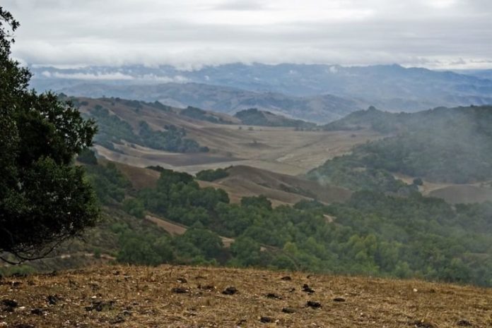
It never fails. A hard effort always wins a great reward, and the view from Bill’s Hill was grand. Cañada Road traced the valley on the other side of Osos Ridge. Beyond, the view reached to Gilroy, Fremont Peak, and over to Hollister. The surprise was the view of the lower portion of Cañada de los Osos – a broad and secluded pastoral valley so rare in these tightly corrugated hills.
The round trip was seven miles in all: some strolling; a tough climb; wonderful views. Check your map and watch for the rock cairn. Be prepared to cross the fence. When you do, park people have assured me, you are not trespassing.


