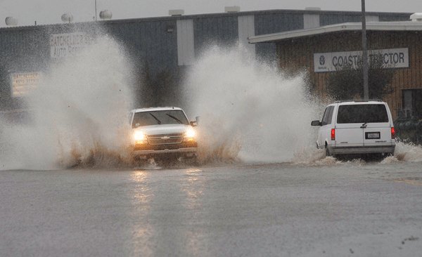
A powerful storm that blew through the region Thursday night
drenched Gilroy with three inches of rain as of 4 p.m. Friday. The
howling wind and driving rain caused localized flooding, knocked
down power lines and caused several accidents.
A powerful storm that blew through the region Thursday night drenched Gilroy with three inches of rain as of 4 p.m. Friday. The howling wind and driving rain caused localized flooding, knocked down power lines and caused several accidents.
With only five inches of rainfall before the storm hit, Gilroy has received 60 percent more rain in the last 24 hours than it had in the last six months.
Although 910,000 Pacific Gas and Electric customers from Bakersfield to Eureka experienced power outages as of 2 p.m., only about 80 Gilroy residents were without power, said Brian Swanson, a PG&E spokesman.
“There’s widespread damage throughout our service area,” he said.
The majority of the problem areas in Gilroy occurred along Longmeadow Drive west of Santa Teresa Boulevard including the Rancho Hills and Country Estates developments and power was lost around 11:30 a.m. Friday, Swanson said. Residents are still awaiting restored power.
Water gushed out of drainpipes and ran into street gutters in Gilroy’s residential sections. Although the city has not closed any of Gilroy’s roads, drivers inched along the flooded roads with caution. Sections of Monterey Road, Luchessa Avenue, Chestnut Street and Burchell Avenue are flooded and a vehicle skidded off Highway 152 between Ferguson and Canada roads.
A high wind advisory is in effect over Pacheco Pass and travel is not recommended for campers or trailers. Hecker Pass is closed 2.2 miles east of the Santa Clara/Santa Cruz county line due to downed power lines and motorists are advised to use an alternate route. U.S. 101 is closed to northbound traffic at Coyote Creek Road due to an accident. A detour is available.
Las Animas and Christmas Hill parks were closed at 2 p.m. Friday due to severe flooding.
Assistant City Administrator Anna Jatczak said that every city department – police, fire and public works – was out monitoring the situation.
“They will be working as long as necessary,” Jatczak said, acknowledging that the storm is supposed to persist into the weekend.
“But most everything is under control at the moment.”
“We were quite lucky compared to the city of Morgan Hill,” she said.
Morgan Hill did not fare as well. Roads all over the city have been closed down due to flooding and the Morgan Hill Downtown Association urged shop owners to close down for the day. Morgan Hill police cruisers and public works vehicles cordoned off major city thoroughfares as the flooding worsened over the course of the day.
Road closures include:
– Butterfield Boulevard between Main Street and Tennant Avenue
– Del Monte Avenue
– Watsonville Road between Monterey Road and Santa Teresa Boulevard
– Portions of Monterey Road
– All side roads off La Crosse Drive
– Portions of Crest Avenue
– Church Street at San Pedro Avenue
The stretch of Monterey Road near Spring Street in front of the Sun Valley Market floods almost every rainstorm, said George Seoud, the convenience store’s owner. Taking matters into his own hands, Seoud was unclogging the storm drain into the Llagas Creek, which runs behind his business.
“When it rains really hard, I always have to clean out that drain, there’s nothing we can really do but let Mother Nature run its course,” he said.
Morgan Hill city officials activated the emergency operation center to coordinate a response to the massive flooding. Morgan Hill City Manager, Ed Tewes, said the center would be up and running about 2 p.m. Friday and he would oversee the effort.
A high wind advisory and flash flood watch issued by the National Weather Service is still in effect for the Santa Clara Valley until noon Saturday. The NWS said up to five inches of rain could fall by the end of Friday. Gilroy can expect temperatures in the low 50s and high 40s for the weekend with heavy rain, scattered thunderstorms and wind gusting up to 20 mph.


