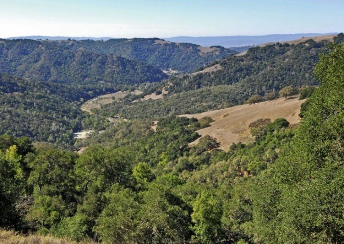
At 87,000 acres, Henry W. Coe State Park is the largest and wildest state park in northern California. But for all the park’s size and diversity, it lacks one precious commodity: accessible flat terrain.
The opening of the Hunting Hollow entrance on Gilroy Hot Springs Road past Coyote Reservoir, finally gave Coe Park visitors easy access to level land. But as you walk out Hunting Hollow Road, Willson Peak looms on your left tempting you with the promise of vast views above. And indeed, they are up there, but the price is high.
Many of the trails at Coe Park are simply old roads cut by cattle ranchers suited for four-wheel drive trucks with compound low gears – gears that most of us don’t possess. An unreliable source told me that climbing Willson Peak was among the “enhanced interrogation” techniques approved by the government for suspected terrorists. Suspects who brushed off water-boarding cracked half way up the Middle Steer Ridge Trail. “No more! I’ll tell you everything. Just no more.”
Coe volunteers to the rescue. Ushering in and age of humane enlightenment, volunteers are realigning the Jim Donnelly Trail so we can enjoy the climb to those special views.
If you have walked out Hunting Hollow Road, you know that it crosses the creek several times. This is a bit of a nuisance in spring, but this time of year, I found the creek bed dry. To reach the foot of the old Jim Donnelly Trial, you had to walk Hunting Hollow Road to the windmill then go a short distance up the Middle Steer Ridge Trail. I found the new trailhead just past the first creek crossing only a few hundred yards from the parking lot.
The trail switches back and forth rising gently through a lovely forest of blue oaks. Up a short distance, the route crosses for the first time onto the north side of a spur ridge and into a cooler and wetter environment. Blue oaks are replaced by coast live oaks and bay trees for a nice change of pace and a cool break from the hotter south side.
Up, up I went until the oak forest thinned and the views took center stage. As the trail crosses from one side of the ridge to the other, the views alternate from looking up Hunting Hollow Road on one side to down Coyote Creek and Gilroy Hot Springs Road on the other.
The Jim Donnelly Trail meets the Steer Ridge Trail at nearly 2,200 feet, 1,300 feet above the parking lot. If I had climbed this high up Willson Peak by any other route, I would surely be weeping and calling for my mommy, but there I stood with view of Monterey Bay feeling like I had simply been sipping port on the lanai.
I returned down the Steer Ridge Trail which underscored the elegance of the new Jim Donnelly Trail. The pitch is so steep and the footing so precarious in places, that an inexperienced hiker is nearly guaranteed to come home with matching fanny strawberries. It is counter intuitive, but when you descend steep trails with loose soil, lean as far forward as you can without becoming a runaway train. This puts your body weight more directly over your feet. If you lean into the hillside, you tend to push your feet out from under you.
Kudos to Paul Liebenberg and the crew that has built this trail. Their hard work, evident every step of the way, means our job is easier.


