SOUTH OF Monterey, the Santa Lucia Range rises boldly from the Pacific Ocean and parallels the coast southward for 105 miles. We know the range best for the local Big Sur coastline, where beautiful sheer conifer- cloaked cliffs plunge into the sea. But the range also has an inland side that rises above the Salinas Valley. While the Big Sur coast gets all the attention, the east side has a hidden nook that I promise will surprise and amaze you.
In late January, I set out to hike up Junipero Serra Peak, at 5,862 feet, the highest peak in the Santa Lucia Range. The twelve-mile round trip to the peak was a difficult but rewarding climb—a long hard day. But it was one of my most memorable days, as much for the country I drove through as the climb to the summit.
I exited Highway 101 onto Jolon Road just north of King City. Eighteen miles down the road, I turned onto Mission Road and the entrance to Hunter Liggett Military Reservation. In the past, I have always been asked for my driver’s license, vehicle registration, and evidence of insurance. I don’t know why, but on this trip no sentry was at the gate, and I drove right through. If you come, it’s best to be prepared. Five miles into the base, I turned left onto Del Venturi Road, and the show began.
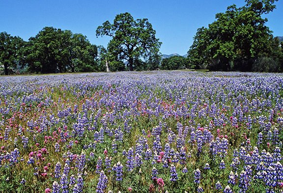
For the next seventeen miles, the Santa Lucia Range rose rugged and inhospitable on each side of the road. But the valley floor close by the road was everything the tangled hills were not. Wide and level, an expansive oak savanna set on a lush carpet of green grass stretched on and on, each scene enticing curious wanderers to stop and explore. What is such an elegant and gentle valley doing here amid this deeply corrugated tangle of mountains? So surprising, and so beautiful.
I was last there in 2005 to see an amazing wildflower display. Will a wet winter after four years of drought bring another gaudy flower show this spring? No flowers yet, but the valley was no less enchanting without them.
Resisting the valley’s allure, I pressed on to the trailhead. There it was, Junipero Serra Peak, six miles and 4,000 vertical feet above me. The first couple miles rose gently across the base of a mountain bulge, then made a slow left turn around it into a drainage where climbing began in earnest. Dense chaparral—scrub oak, manzanita, chamise, and an occasional yucca—cloaked the mountain. Evidence of the 2008 Indians Fire was everywhere. Every shrub across the slope had a black-burned snag protruding above the recovering foliage.
I topped a ridge perhaps a mile from the summit, weary, but oh so close. Here, the landscape stepped in to lift my spirits. A forest of Coulter pines and robust sugar pines shaded the final steps to the summit. The top of Junipero Serra Peak is a broad and wooded Sierra-like parkland littered here and there with wreckage of an old fire lookout and other abandoned infrastructure. As usual, a great effort won me a great reward. To the west, beyond innumerable peaks, lay a vast stretch of the Pacific Ocean. Inland, as well as up and down the range, a succession of ridges and valleys disappeared in the distance.
The climb up Junipero Serra Peak is ambitious and exhausting. Whether you tackle it on or not, exploring lands along Del Venturi Road is a must. For more photos, complete directions, and important information I couldn’t include here, go to https://www.facebook.com/RonGettingOut.


