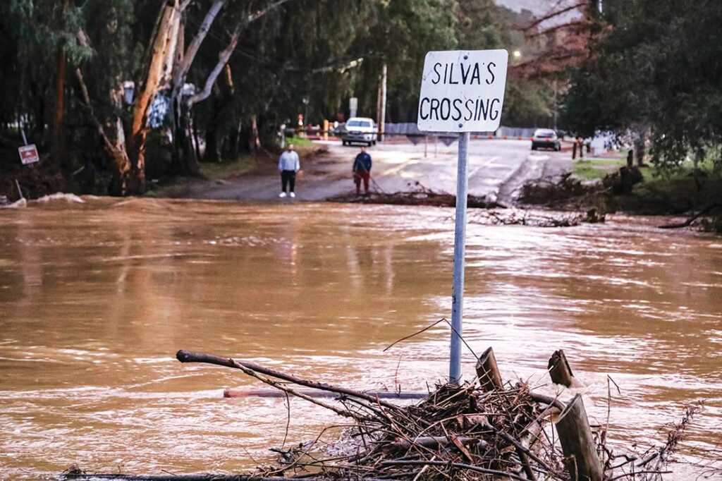
Highway 101 in Gilroy was shut down for more than six hours on Jan. 9 after Uvas Creek spilled over near Mesa Road, submerging multiple homes and turning the heavily traveled roadway into a slow-moving river.
Highway 25 south of Gilroy was reportedly briefly closed as well, while fallen power lines shut down Monterey Road between Ronan Avenue and Pierce Street, and Uvas Creek rushed over Miller Avenue at a height many say they haven’t seen in years.
Shortly after the County of Santa Clara announced a local emergency Jan. 4 due to heavy wind and rain pounding the region, officials issued evacuation warnings for those living near the Uvas Reservoir in Morgan Hill and the Pacheco Pass River Basin east of Gilroy. On Jan. 9, that warning was extended to the areas surrounding Highway 101 and Bolsa Road.
Although the latest storm in Gilroy on Jan. 9-10 was one of the strongest of the season so far, dumping nearly three inches of rain, according to the National Weather Service, city officials said no significant damage or incidents were reported despite high winds and widespread flooding on waterlogged creek banks and roadways.

Emergency public safety responders rescued nearly two dozen people and 16 animals from their homes near the Santa Clara/San Benito county line as pouring rains and rising floodwaters engulfed homes, streets and properties Jan. 9, according to authorities.
A total of 23 people were rescued from Lovers Lane, starting in the early afternoon, according to San Benito County Public Information Officer Monica Leon. Of the 16 animals rescued, 15 were dogs and one was a cat.
The rescue efforts were complete by early in the evening Jan. 9, Leon said. No injuries were reported.
More than 35 response units from the San Benito County Sheriff’s Office, Hollister Police Department, CalFire, Hollister Fire, San Benito County Search and Rescue and animal control services were on scene to assist in the emergency rescue.
The rescued residents had stayed at their homes despite numerous flood warnings and evacuation notices throughout the week—which escalated to a mandatory evacuation order by around noon Jan. 9. County officials had begun warning Lovers Lane residents to prepare to evacuate on Jan. 4 as Pacheco Creek looked to be on pace to swell over its banks, Leon noted.
Sheriff’s personnel went door to door to notify residents of the danger in person, and tacked paper notices on the homes where there was no answer, Leon added.
When the order to evacuate was called on Jan. 9, emergency responders set up a mobile command site near Lovers Lane, knowing that some residents were still home, Leon explained.
By the time the Jan. 9 rescue operation started, only 11 people in the evacuation order zone had voluntarily left, and 80 either did not answer the door or declined to leave their homes, Leon said. Even as emergency responders were rescuing some Lovers Lane residents, 39 people still refused to leave their flooded properties.
“Water rises fast, and there was a significant amount of rain to create this flooding,” Leon said.
With the ground saturated from a line of strong storms in recent weeks, many waterways in the region didn’t have much time to subside before the latest downpour, according to weather experts.
The residents and animals who were rescued Jan. 9 were transported to a temporary evacuation center established at the Hollister Veterans Memorial Building.
Break on the way?
The latest weather forecast might not include sunny skies, but some relief from the heavy downpours that have been characteristic of recent storms over South Valley might be on the way.
After the latest atmospheric river on Jan. 10 cleared the region, there will be an “unsettled pattern” for a couple of days, National Weather Service Meteorologist Sean Miller said. Jan. 11-12 will see chances of rain from Morgan Hill through Gilroy to Hollister, with precipitation projections less than .25 inch.
Then, starting Jan. 13 and lasting through the weekend will be the “next stronger weather system,” Miller said. “It’s not looking on the order of what we just had (but) some areas could see a half inch to an inch of rain, or more.”
That storm will likely last through Sunday, which marks the end of Miller’s Jan. 10 forecast period.
Temperatures through Sunday will be somewhat normal for the season, with highs in the upper 50s to 60, and lows in the upper 40s to lower 50s, Miller said.


